Feature articles
Agroforestry, basic situation, challenges and opportunities
Agroforestry, a scientific field that is currently in the news because of the numerous debates on environmental aspects of human development, is an ancient practice that exists on all continents. It is a result of the farmer’s desire to diversify and intensify his cropping system. This practice, widely researched as it is, must now be promoted more efficiently, primarily to governments, through an improved structuring of existing knowledge networks.
8/06/2010
Is agroforestry a suitable response to climate change?
The exploitation of natural resources – land, water, biodiversity is reaching saturation point and this is compounded by expanding population growth. The degradation of the natural forests is aggravating the impact of climate change. Agroforestry systems, can contribute to the mitigation of the effects of climate change, mainly by improving the microclimate and the biodiversity and the attainment of food security goals. Peri-urban agroforestry also deserves consideration in the context of the diminution of arable lands near inhabited areas. Responding to climate change requires an unprecedented mobilization of the international scientific community who must rethink paradigms which previously guided research for development agendas.
8/06/2010
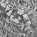
How do satellite images and airborne imagery relate to agriculture and forestry?
Satellite and aerial imagery play a significant role in modern day agricultural production and forest related activities. T he primary value of satellite and airborne imagery to agriculture and forestry is two-fold. Firstly, imagery provides valuable information that is useful for planning and managing the potential crop output, in a sustainable way. Imagery results in more sustainable food production. Secondly, imagery enables the gathering of knowledge about agriculture and forestry through local to regional to global scales. That knowledge enables a better understanding of overall production factors, but also contributes toward risk management decisions and supports predictive modelling of food supply and consumption. This article gives a thorough account of the applications of satellite imagery and GIS used in the agriculture and forestry sectors.(Vector1media, 13 May 2011)
1/07/2011
E-mail Newsletter
Interact with us
Members
- Is the innovation systems approach the answer to inclusive development?
- CTA Top 20 Innovations that Benefit Smallholder Farmers
- Enhancing private sector engagement in agricultural research and development in eastern Africa
- Intellectual property rights in plant breeding and the impact on agricultural innovation
- The ethics of animal production and sustainability